1940 - 1970
The 1940’s to the 1970’s in Seattle were a time of balance between planning commissions bolstering plans to rejuvenate the economic dominance of the urban area and groups of citizens pushing for open, aesthetic spaces and preservation of historical sites. With the ebb and flow of success of one of Seattle’s most famous aerospace corporations, Boeing, through war and peace times, jobs came and went. However, the population continually grew and suburban areas exploded and moved further and further from the urban core. This process of decentralization led to an urban decline that had to be remedied. Freeway plans and improvements to the central business district were created within the 1956 Seattle Comprehensive Plan. The growing issue of pollution in Seattle’s lakes was remedied by James Ellis’ brainchild METRO and the federal Model Cities Program improved areas of deterioration. This period of time witnessed a growth of parks and recreation through the Public Works Program and the Forward Thrust Movement. Finally, we look at the impact of anti-Japanese American sentiments in the wake of the Second World War.
Despite being one of the key highlights of this era, Boeing’s presence in Seattle does not require much of an urban planning analysis as nearly all of its manufacturing needs were outsourced and the core of work done in Seattle was engineering and assembling. By 1947, Boeing employed 20 percent of all workers in King County. However, with no actual manufacturing being done in Seattle, there were few if any opportunities for other businesses to benefit from this.[1] Thus, there was very little planning consideration given to supporting Boeing in any of its stages. Boeing’s largest contribution to planning in this period is being the cause of a huge population increase, which can be attributed as a cause for the expansion of the freeway system, the suburban housing boom, and the need to address “metropolitan ills.” These new conditions created a need for new forms of planning. The sudden decline of urban life after the Second World War was met with a rise in urban planning efforts. The most notable planning documents were the 1956 Seattle Comprehensive Plan and the 1963 Plan for Central Business District, Seattle, or the Monson Plan. While planners were working to solve the issue of urban decline, growing pollution issues were addressed by one of Seattle’s earliest official planning committees, Municipality of Metropolitan Seattle (METRO).
The downtown of the mid-twentieth century was a failing real estate market and contained a central business district (CBD) perceived to be failing as well. One cause of this was the growth of suburban life resulting in decentralization. Data to support this indicates that Seattle’s suburban population grew 46 percent compared to an urban population growth of only 0.7 percent from 1950 to 1960.[2] Business and commercial activity in the city were weakening alongside real estate. Seeking to remedy this problem, the Planning Commission appointed John Spaeth as its director and before long, the Comprehensive Plan of Seattle was produced in 1956. This plan served to guide urban land use and transportation planning and could be broken down into three main sections: the Land Use Plan, the Arterial Thoroughfare Plan, and the Community and Neighborhood plan. After the release of this comprehensive plan, more urban plans would follow, all with the emphasis of restoring economic stability to downtown areas by defining central business district areas and functions. [2]
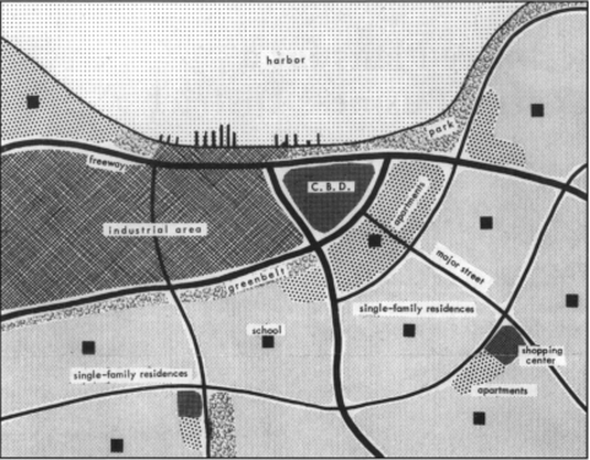
An early plan for restoring the health of the downtown Seattle core. Public and private land as well as the CBD are denoted.
The goal of these plans was to optimize the urban space within the central business district in hopes of making the downtown area competitive with the ever-growing suburban markets. This involved defining CBD-use and non-CBD use entities. For example, trendy offices and parking garages would fall under CBD-use whereas bars and pawnshops would fall under non-CBD use. The city conducted a survey of the city in 1958 called Seattle’s Central Business District: A Land Use Study. This survey served to identify non-CBD areas that were attributing to devaluation of the downtown area. They found fringe areas of non-CBD use to have the highest deterioration and vacancy. These areas of blight were ideal for redevelopment. Also at this time, Seattle established its Urban Renewal Division as a response a federal urban renewal law. Alongside renewal, further efforts to galvanize economic success in the downtown area included the planning of a ring-road system of freeways and the bringing of the world fair to Seattle. [2]
The Monson Plan in 1963 created a clash between proponents of economic revival and urban renewal and proponents of historical preservation. Monson’s plan envisioned pedestrian malls, networks of roads to bring people to these businesses, and parking garages to facilitate an influx of business. He viewed areas of blight as areas that needed to be completely redeveloped and with funds given by the federal government. Advisors who played a large part in the creation of this plan targeted Pioneer Square and Pike Place Market as two especially negative fringe areas. The idea would be to completely level these places and replace them with offices, parking structures, stores, and other CBD-use infrastructure. However, these plans would fail due to timing. The view on what constitutes a healthy downtown began to shift from redeveloping aging fringe areas to preserving them. The National Historic Preservation Act of 1966 and the Demonstration Cities and Metropolitan Development Act of 1966 made the Monson Plan feel obsolete and it was never implemented. [2]
The Monson Plan in 1963 created a clash between proponents of economic revival and urban renewal and proponents of historical preservation. Monson’s plan envisioned pedestrian malls, networks of roads to bring people to these businesses, and parking garages to facilitate an influx of business. He viewed areas of blight as areas that needed to be completely redeveloped and with funds given by the federal government. Advisors who played a large part in the creation of this plan targeted Pioneer Square and Pike Place Market as two especially negative fringe areas. The idea would be to completely level these places and replace them with offices, parking structures, stores, and other CBD-use infrastructure. However, these plans would fail due to timing. The view on what constitutes a healthy downtown began to shift from redeveloping aging fringe areas to preserving them. The National Historic Preservation Act of 1966 and the Demonstration Cities and Metropolitan Development Act of 1966 made the Monson Plan feel obsolete and it was never implemented. [2]
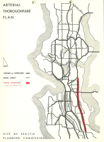
Arterial Thoroughfare Plan from 1957. The proposed R.H. Thomson Freeway is highlighted in red.
The other component of the 1956 Seattle Comprehensive Plan was on the transportation side and it experienced a similar fate to that of the urban land use side. Within this document, there was a plan for a network of freeways that surround the core of the city, known by some as a “’ring-road’ system.”[3] Two historical freeway plans within this envisioned network are the plan for the R.H. Thomson Freeway and the Bay Freeway. Both of these freeway plans would experience strong positive public and private opinion initially. As planning for these freeways went on, it became clear that these freeways would cut through areas originally zoned for residential and park use. As a result the popularity for these freeways plummeted and the plans were never fully implemented.
The R.H. Thomson Freeway was to be a north-south freeway planned in the 1950’s with the functional intent of relieving traffic on the I-5 and providing a way to bypass driving through the city. The key oppositions to this plan were the necessary removal of thousands of homes in densely populated areas as well as the plan to build the freeway right through the Arboretum. Destroying areas zoned for parks and recreational use went against the idea of the City Beautiful Movement and thus was a very unpopular idea. Before long, the City Council cut funding and the interests of the residents won out over the interests of freeway proponents. The original plan for SR-520 incorporated exits leading to the R.H. Freeway. These exits are now landmarks known as “roads to nowhere” and symbolize a time when the people seized the planning process in Seattle. [3]
The Bay Freeway was an east-west freeway project created in 1954 with the functions of improving traffic flow, connecting I-5 with the Seattle waterfront, and improving access to certain urban areas. Consideration to aesthetics was given during its planning way by promising to not hinder the view of Lake Union and conform to the architectural theme of Seattle Center facilities. The planners intended for the Bay Freeway to cut through park areas as a way of giving the freeway a nice edge as one travels down it from the I-5.[3] An interesting thing about the Bay Freeway is the identity of the planners responsible for its conception. “Planning, design, and construction of the Bay Freeway is the responsibility of the City of Seattle, Department of Engineering.”[4] This is unique from the modern way of planning where a group of people who are well-versed in a number of policy such as public policy, environmental policy, etc. will lay the ground work for the technical people who will then take over the implementation of a project. In this old way, the engineers are being used as an all-purpose group. One might infer this to be the cause of the lack of consideration given to the opinions of the public and the intent of previous land use planning where the Bay Freeway would exist. By around 1970, residents felt that the City Council had let the plans differ too far from what voters authorized in 1960 and the Bay Freeway was never realized.[3]
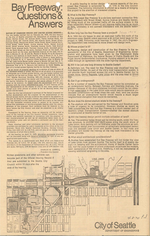
A Q&A found in Seattle Municipal Archive. Background and design intent questions are answered.
Stepping back, another consequence of the population boom in this era was the growing pollution of local lakes. As the population grew, so did the amount of waste produced. With no group in charge to regulate environmentally conscious policies, sewage plants were dumping effluent, a term to describe liquid waste, into Seattle’s lakes at increasing rates. According to history.org, “There were 10 different sewage treatment plants discharging effluent into Lake Washington.” James Ellis emerged and suggested that a new form of government should come into existence. This body would address regional concerns such as public transportation, traffic issues, environmental concerns, and so on. In retrospect, what Ellis was describing reflects our modern day planning commissions. After a few elections, the Municipality of Metropolitan Seattle, or METRO, was born in 1958. However, they were only given jurisdiction over pollution-related decisions. METRO would later on become the group responsible for transportation planning decisions but this would not occur until after 1970. METRO adopted a comprehensive sewer plan under which the 10 previously mentioned sewer plants were to be shut down and all the other sewer plants in Seattle and nearby regions would fall under control of METRO. To replace the shut down sewer plants, METRO hired a group called Metropolitan Engineers to design and build new sewer systems. After constructing a system of tunnels and pipelines to divert sewage from being discharged in Lake Washington, the pollution issues that arose in the wake of the population boom were resolved.[5]
While on the topic of sustainability and still within the vein of the effects of the population boom, it would be appropriate to mention the effects of the 1966 Model Cities Program on Seattle. The main goal of the Model Cities Act was to improve the quality of urban life. In Seattle, a committee was formed with the purpose of selecting the urban area to use the funding on. They chose the Central Area, Pioneer Square, and the International District. Ten percent of Seattle’s population lived in this region and within this 10 percent existed 61 percent of the city’s non-white population.[6] This choice was most likely made due to the trend of diverse urban areas becoming places of a lower quality of life. A requirement of the Model Cities Act was to generate a Comprehensive Plan before funding was dispersed. Walter Hundley was chosen as program director and was able to come up with a draft in 1968 focusing on nine key elements of improvement in urban life. As the 1970’s came to a close, the Seattle Model Cities Program proved to be successful in planning, developing, and implementing a number of these quality-of-life programs. Some examples of these programs include arts and culture, education, housing, and welfare. [6]
Moving on to the topic of parks and recreation, Seattle experienced a growth in this arena as a result of the Federal government initiating a public works program in the midst of The Great Depression. Some examples include E.C. Hughes Playground, Matthews Beach, and the Arboretum. The rise of these places came as a result of a study, a plan, and an implementation. The Seattle Zoning Commission conducted the study. Originally, this commission only worked in real estate but began to cover more areas when, in 1946, they were given a staff and a larger budget. Their study was called “Comprehensive Plan for Seattle” and in this, they focused on zoning, highways, parks, etc.[7] In 1954, they drafted a report called “Planning for Recreation” involving such topics as land use, arterial thoroughfares, and community and neighborhood boundaries. The central purpose of this plan was to locate and integrate parks, playfields, recreational centers, and similar facilities. A highlight of this plan, and something that relates to the freeway section earlier in this narrative was the conversion of the “Central Freeway” to Interstate 5. The implementation of this plan came in 1958 by way of a program called the “Betterments Program.” [7]
Other growths in parks and recreation stemmed from the federal government’s 1961 Open Space Program. Within this program, any agency was able to apply to receive funding by developing an “Outdoor Recreation and Open Space Plan.” The staffs of the park department and of the planning commission crafted Seattle’s plan in 1965. Within the plan, there were standards established for parks and recreation, an inventory of park and school facilities, an exposition of deficient areas, and a prioritized action program meant to bring the city up to national standards. Around the same time, James Ellis, the previously mentioned “father of METRO,” organized the Forward Thrust Movement. Within this movement, a “Committee of 200” assessed needs of Seattle and prepared 13 separate bonds. These were voted on and a number of them passed. From the Forward Thrust Movement, we see such highlights as Waterfront Park. [7]
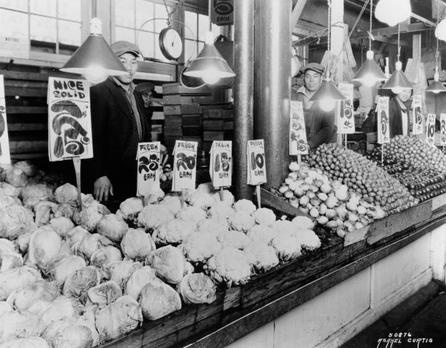
A Japanese-American fruit vendor at Pike's Market
An interesting case study to look at during this time period is the impact of the internment of Japanese-American citizens around the time of the Second World War. This should be approached from three different periods: the time before internment, during internment, and after internment (commonly referred to as “resettlement”). Prior to the war, Japanese-Americans did a large bulk of farming and it was local farming that caused Pike’s Market to be such an explosive success.[8] Pike’s Market even thrived through the Depression. However, after the Japanese were sent to internment camps, Pike’s Market took a hit that would leave it in decline for a while. Even once the Japanese resettled into urban Seattle, the new generations of Japanese did not follow the farm life. [8] The market was viewed as a deteriorated entity hardly worthy to exist on the fringe of the central business district. It was this very reason that the Monson Plan of 1963 called for it to be redeveloped into a modern Pike’s Plaza. [8] A secondary thing to note regarding resettle of Japanese-Americans was the services being provided to aid them. The government of Seattle was resisting internment so the Seattle Council of Churches stepped in. The council established hotels to serve as temporary housing and created a program to help with jobs, housing, social services, and more. These community services were helpful in resettling the Japanese, restoring Seattle’s prewar demographic.[9]
References
1. Sale, Roger (1976), Seattle: Past To Present, Seattle and London: University of Washington Press
2. Park, Sohyun. “Perspective Plans for a Healthy Central Business District.” The Pacific Northwest Quarterly Summer 2007: 107-13.
3. Crowley, Walt. “Seattle voters scrap proposed Bay Freeway and R. H. Thomson Expressway on February 8, 1972.” HistoryLink.org. 19 March 2001 http://www.historylink.org/index.cfm?DisplayPage=output.cfm&File_Id=3114
4. Carrol, Charles M. “Bay Freeway: Questions & Answers.” Seattle Municipal Archives
5. Oldham, Kit. "Metro: Municipality of Metropolitan Seattle.” HistoryLink.org. 18 June 2006.
6. “Seattle Model City Program.” Virginia.edu http://socialarchive.iath.virginia.edu/xtf/view?docId=seattle-model-city-program-cr.xml
7. Sherwood, Donald N. “Interpretive Essay on The History of Seattle's Parks & Playgrounds.” Guide to the Don Sherwood Parks History Collection. Don N. Sherwood. 13 July 1979. http://nwda.orbiscascade.org/ark:/80444/xv19503
8. “Pike Place Historical Market District.” Seattle.gov http://www.seattle.gov/neighborhoods/preservation/pikeplace_history.htm
9. Speidel, Jennifer. “After Internment: Seattle’s Debate Over Japanese Americans' Right to Return Home.” Seattle Civil Rights & Labor History Project 2005. http://depts.washington.edu/civilr/after_internment.htm
Images
(Images listed in order that they appear)
1. Retrieved from http://www.jstor.org/stable/40492027?seq=1
2. Retrieved from http://www.flickr.com/photos/seattlemunicipalarchives/3407349940/
3. Retrieved from http://www.flickr.com/photos/seattlemunicipalarchives/5301133120/in/photostream/
4. Retrieved from http://www.pikeartproject.org/scenes.htm
