Current Developments
All current progress and developments are handled and orchestrated by Seattle Department of Planning and Development which strives to engage citizens in an ongoing dialogue about Seattle's future and continues to play a central role in guiding the long-term development of the built and natural environment[i]. As told in their vision statement, they seek to build a more dynamic and sustainable Seattle by partnering with the community to build and preserve the city economically, socially, and equitably.
Their endeavors are guided by the 2004-2024 Comprehensive Plan. It was first created in 1956 and then recently updated in 2004 with the most recent amendments added in 2012. The City of Seattle’s Comprehensive plan, Toward A Sustainable Seattle, is a 20 year policy plan designed to articulate a vision of how Seattle will grow in ways that sustain its citizens’ values [ii,a]. Further, it was constructed with a flexible framework so that initiatives and goals could be adapted as needed overtime to fit modern contexts. The Plan continues to guide Seattle’s development by a set of four core community values:
The four core values, as described above, constitute the embodiment of sustainability—and in this plan work to promote development that protects, reflects and advances these core values as Seattle continues to grow [ii,c]. As the city is projected to acquire about 47,000 new households and 84,000 jobs within the 20-year period, where this growth occurs has enormous impacts on local and regional environmental quality, neighborhood quality-of-life, economic opportunity, and the overall costs of development. As such, the essential goal, to this end, is to steer most of this projected growth towards urban centers and urban villages. To this end, the Plan intends to utilize the Urban Village Strategy as an overarching guide of city development which is stipulated in the recently added Urban Village Element.
Their endeavors are guided by the 2004-2024 Comprehensive Plan. It was first created in 1956 and then recently updated in 2004 with the most recent amendments added in 2012. The City of Seattle’s Comprehensive plan, Toward A Sustainable Seattle, is a 20 year policy plan designed to articulate a vision of how Seattle will grow in ways that sustain its citizens’ values [ii,a]. Further, it was constructed with a flexible framework so that initiatives and goals could be adapted as needed overtime to fit modern contexts. The Plan continues to guide Seattle’s development by a set of four core community values:
- Community
- Environmental Stewardship
- Economic Opportunity
- Social Equity
The four core values, as described above, constitute the embodiment of sustainability—and in this plan work to promote development that protects, reflects and advances these core values as Seattle continues to grow [ii,c]. As the city is projected to acquire about 47,000 new households and 84,000 jobs within the 20-year period, where this growth occurs has enormous impacts on local and regional environmental quality, neighborhood quality-of-life, economic opportunity, and the overall costs of development. As such, the essential goal, to this end, is to steer most of this projected growth towards urban centers and urban villages. To this end, the Plan intends to utilize the Urban Village Strategy as an overarching guide of city development which is stipulated in the recently added Urban Village Element.
Urban Village Element
Urban villages are community resources that enable the City to: deliver services more equitably, pursue a development pattern that is environmentally and economically sound, and provide a better means of managing growth and change through collaboration with the community in planning for the future of these areas [iii]. The urban village strategy tries to match growth to the existing and intended character of the city’s neighborhoods. It divides up Seattle’s potential urban villages into four categories which will play integral roles in future development:
- Urban centers—the densest neighborhoods with a diverse mix of uses, housing and employment opportunities.
- Manufacturing/Industrial Centers—vital to the health of Seattle’s economic regional resources.
- Hub urban villages—communities that provide a balance of housing and employment yet aren’t as dense as urban centers
- Residential urban villages—aimed to provide goods and services for residents, but not necessarily employment
Center City Seattle Strategy
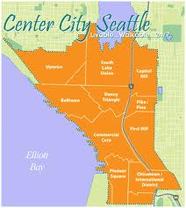
P.1 The 10 neighborhoods of Center City
The policies for this element come to fruition in the projects in the Center City Seattle Strategy. This strategy recognizes the importance of, with the projected city growth, it is vital to have a strong central core while also strengthening its nine surrounding neighborhoods to represent a new urban identity for Seattle. This entails focusing strategic planning efforts that meet the aims to grow a vibrant economy in downtown Seattle, build transportation solutions, foster great neighborhoods, build a sustainable future and create housing options [iv]. With these, Seattle will embody smart growth at its best in fighting urban sprawl and building a sustainable economy and community. The neighborhoods involved in this strategy include Uptown, South Lake Union, Capitol Hill, Belltown, Denny Triangle, Pike and Pine, First Hill, the Commercial Core, Pioneer Square, and the Chinatown/International Distrct. The proposed projects, currently underway, respective to the strategy include:
- Center City Public Realm Strategy---Public realm improvements in the urban core neighborhoods will provide tremendous opportunities to advance regional smart growth objectives and to enhance economic competitiveness. As the 10 neighborhoods are designated to absorb a large amount of the city’s projected growth, designing connections and character developments in a common direction have the ability to create livable spaces that are attractive to residents, businesses, shoppers, and visitors [v]. These endeavors are headed by CityDesign, Seattle’s urban design planning office.
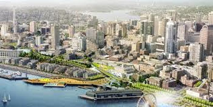
- Central Waterfront
This project involves the Alaskan Way viaduct and the Elliot Bay Seawall along the central waterfront that have been damaged and weakened, thrusting the central waterfront towards yet another major milestone in its evolution. City planners are working to remove and replace both and redevelop them for public benefit[vi,a]. These projects open up new public space—from the Olympic Sculpture Park to Pioneer Square—for parks and paths, access to the water, places to enjoy views, vibrant public and cultural spaces, and a new urban street that will accommodate all modes of travel and provide an important connection in the City’s transportation system.
As reported in the Waterfront Seattle Strategic Plan : “The idea of improving our waterfront was generated by grassroots interest more than a decade ago, paving the way for the current waterfront Concept Design and Framework Plan developed by the City and its consultant team. This design work is based on an extensive, nearly two‐year public outreach effort that has creatively and successfully engaged thousands of citizens in the process of realizing the waterfront vision and its specific design elements. The proposed improvements will connect the city and its people to the waterfront, create a variety of signature public places for socializing and recreation, enhance the ecological fabric of the urban waterfront environment, rebuild critical structures to improve public safety, and project a new image and identity for the city that draws from the authentic character of adjacent neighborhoods and the working waterfront.” [vi,b]
P.2 Central Waterfront Vision
Implementation will entail specifying the design concepts to provide the exact information needed for environmental review and permitting. The type of environmental review and permits will largely depend on whether in-water work is involved and the potential for significant impacts [vi,c]. This approach allows flexibility to move projects forward and ensures each improvement will have appropriate, detailed review
3. Blue Ring Strategy
Since 1999, CityDesign has been leading the development of the Blue Ring, Seattle’s open space strategy for the Center City. Conceived as a companion to Olmstead's green ring of parks and parkways that encircle Seattle outside of the Center City, the Blue Ring will connect the Center City's assets and amenities, such as the waterfront, the Seattle Center, and Occidental Park [vii,a].This project was created from the idea that without a well-defined open space, the Center City will become just another large, oppressive metropolis with no sense of “place” for public social gatherings, recreation, or enjoying the urban lifestyle. Open-space amenities are needed to make such areas more livable [vii,b].
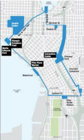
Seattle's Blue Ring
The Blue Ring consists of public open spaces and civic destinations—places of regional significance linked by selected public rights-of-way. These places have a diversity of mixed forms and uses; some already exist, while others are in the planning stages. The connecting public rights-of-way will be improved to serve as both pedestrian oriented environments and functional streets for vehicles. [vii,c]. Shoreline improvements to two parts of the Blue Ring, the Waterfront and South Lake Union Park, will provide people with direct access to water.
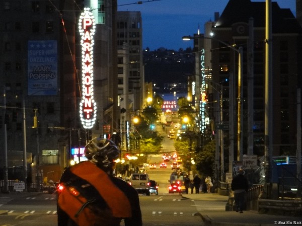
4. Pike and Pine Streetscape Conceptual Design Plan
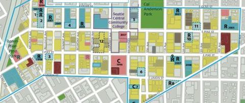
P.4
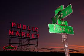
CityDesign aims to enhance Pike & Pine Streets as the heart of the retail core by creating a promenade connecting three premier places: Pike Place Market; Westlake Park and the Convention Center. This will help to encourage the stewardship of
fronting properties, preserve the best from the past, reinforce the heart of
the retail core, develop a front porch and gateway to the Market, create a
promenade connecting the Convention Center, Westlake Park, and the Market,
integrate with Westlake Transit hub, maintain transportation system
functionality, offer sustainable design options, and establish elements of both
continuity and differentiation [viiia].
These goals can be met through actions such as: 1) establishing the block between First and Second Avenues on Pike and Pine streets as the front porch and gateway to the market 2) encourage the presence of small, local retail shops and restaurant and cafés that provide outdoor seating 3) preserving historic buildings and street clocks 4) developing Pike and Pine Streets and their intersections with north/south avenues as the heart of the city’s retail core 5) enhance aesthetics and the sense of civility and safety in the corridor of the proposed promenade 6) reinforce wayfinding at transit tunnel entries and enhance transit information systems 7) retain parking pay stations and on-street parking and 8) retrofit street lighting to reduce light pollution and increase energy efficiePncy[viii,b]..
These goals can be met through actions such as: 1) establishing the block between First and Second Avenues on Pike and Pine streets as the front porch and gateway to the market 2) encourage the presence of small, local retail shops and restaurant and cafés that provide outdoor seating 3) preserving historic buildings and street clocks 4) developing Pike and Pine Streets and their intersections with north/south avenues as the heart of the city’s retail core 5) enhance aesthetics and the sense of civility and safety in the corridor of the proposed promenade 6) reinforce wayfinding at transit tunnel entries and enhance transit information systems 7) retain parking pay stations and on-street parking and 8) retrofit street lighting to reduce light pollution and increase energy efficiePncy[viii,b]..
The aforementioned projects and policy initiatives of the Urban Village Strategy provide direction for the projects and policies detailed in the Neighborhood Planning, Environment, Transportation, and Housing Elements. These not only help to further designate and design the characteristics of urban villages, but the areas surrounding the villages as well.
Neighborhood Planning Element
Neighborhood Planning is the primary mechanism for implementing the goals and initiatives of the Comprehensive Plan into the development of urban centers, urban villages, and manufacturing/industrial centers[ix]. Extensive Neighborhood Plans, as mandated by this program, were officially completed between 1995 and 2000 to manage growth in neighborhoods. Some of their key goals include:
- Giving all community members the opportunity to participate in shaping the future of their neighborhoods.
- Build strong, effective strategies for developing and implementing neighborhood plans
- Help to realize the intent of neighborhood plans for areas that will accommodate the bulk of the city’s growth
- First Hill Revitalization
First Hill is home to over 20,000 citizens with sustainable wage jobs, and is located just over the freeway from downtown. Maintaining a general mix of uses in the neighborhood and providing housing for a larger range of income levels would help to foster the development of market rate and workforce housing [x,a}. It would further help balance the institutional development in the neighborhood. The proposed amendments for the revitalization of this urban village should help restart the projects that had been stalled in the recent economic downturn.
For example, the City recently changed First Hill’s residential parking requirements to better reflect car ownership trends in the neighborhood, based 2000 Census data on car ownership and its excellent transit service and proximity to jobs and services [x,b]. These changes would revise the minimum residential parking requirement for multifamily uses as well as modify the City’s State Environmental Policy Act’s parking policies to be congruent to these policies. - Downtown
The primary goal that focuses development efforts and projects in the Downtown neighborhood is to maintain downtown Seattle as the most important of the region’s urban centers. It thrives as a compactly developed area supporting a diversity of uses meeting the employment, residential, shopping, culture, service and entertainment needs of the broadest range of the region’s population[xi,a]. Certain areas of the Downtown neighborhood have current, specifically-tailored developments that will work cohesively together to continue this livelihood.
o South Downtown
The South Downtown is an area of industrial activity, small businesses, and as well as a hub of regional transportation infrastructure. This area anchors the south end of the Downtown business and government community and is an important part of the aforementioned "Center City Seattle" strategy for housing and economic growth within Downtown and surrounding neighborhoods. The South Downtown Project will increase the density in its neighborhoods through amendments to the current Land Use Code with the goal of stimulating housing and related development [xi,b].
o Downtown Zoning Changes
The changes to the current downtown zoning regulations stem from the Mayor's proposal to provide additional housing by increasing height and density limits in specific areas of downtown Seattle. In May 12, 2006 the new zoning legislation changes went into effect. The changes encourage residential housing in areas outside the main office core and greater office development in the office core[xii,a].
It is estimated that over the next 20 years the new regulations will generate over $100 million for affordable housing, a 60% increase over projections under current zoning. The new zoning rules are an essential component of the vision for the Downtown commercial core and "Center City" and move Seattle forward on two major policy goals: promoting affordable housing and encouraging 'smart growth' in the city and the region[xii,b]. The changes provide strong incentives for building more residential units in the Center City as well as the potential for a significant increase in funding for affordable housing. - Yesler Terrace
For 70 years, Yesler Terrace has provided quality housing for extremely low-income people. As of now, the deteriorating infrastructure makes it increasingly difficult for the Seattle Housing Authority (SHA) to maintain safe and reliable housing at this site. Since 2006, SHA has worked with residents and other stakeholders to shape a development plan that includes replacement housing, additional affordable housing, commercial uses, and public open space[xiii,a]. Yesler Terrace offers a unique opportunity to rebuild a neighborhood from the ground up. Consistent with Seattle’s Comprehensive Plan, redevelopment would increase affordable housing and growth potential within an urban center, building a mixed-use, mixed income community within walking distance of downtown and First Hill medical campuses[xiii,b].
Environment Element
As stated previously, environmental stewardship is one of the core values the Comprehensive Plan strives to embody. It plays a key role in guiding how the City reacts and plans for its projected growth and how they will attempt to meet the needs of the public with the services they provide. Due to the fact that some of the environmental goals compete with other development goals of the city (i.e. economically), this element only purports broad environmental goals and policies rather than specifically tailored ones that might not be coherent with existing plans or are not supported by public sentiment[xiv]. Some of these primary sweeping goals as they relate to planning and economic development call for the City to:
- Protect and improve the quality and function of the city’s air, land, and water resources because of their relationship to human health, wildlife and the region’s natural heritage.
- Maintain a healthy natural environment as central to Seattle’s economic development and as a competitive advantage in attracting and retaining family-wage jobs and workers.
- Reduce fossil-fuel consumption in constructing new and renovating existing City-owned buildings to one-half the U.S. average for each building type.
- Improve the City’s environmental performance, set targets, use innovative approaches, encourage employees, and coordinate with other government entities.
Seattle Urban Forest Management Plan
P.8
The Urban Forest Management Plan is a 30-year plan that recommends guided steps that the City of Seattle should take to preserve its trees and the cherished environment that has come to be called “a city among the trees"[xv,a]. Over the past few decades this title has dwindled as much of Seattle’s urban forest tree cover declined significantly, dropping to 18% of the tree canopy compared to the original 40% that existed 35 years prior. This has the potential to instigate a negative feedback loop such that the loss of treed relief in our built environment reduces livability and further motivates sprawl—which will entail more future development outside of the central city that will eventually degrade those natural environments as well. However, it is key for city planners and developers to realize that balancing urban goals that include managing growth, enhancing livability, protecting the environment, fostering economic growth, maintaining vibrant public spaces, and creating recreational opportunities is challenging and trees contribute to all of these goals[xv,b]. To encourage tree preservation and planting across the city, the Urban Forest Management Plan lays out actions ranging from improving tree care on City of Seattle property to enhancing community outreach to strengthening incentives and regulations during development. The plan also establishes goals for different land-use types and identifies the challenges and opportunities for enhancing the tree canopy coverage within each type [xv,c].
To aid this endeavor, prospective developments will be guided by the Urban Forest Sustainability Model that has been employed by the City. The main sustainability principles in this model that are being used to guide the Urban Forest Management plan include:
To aid this endeavor, prospective developments will be guided by the Urban Forest Sustainability Model that has been employed by the City. The main sustainability principles in this model that are being used to guide the Urban Forest Management plan include:
- Sustainability is a broad, general goal that results in the maintenance of environmental, economic and social functions and benefits over time.
- Urban forests primarily provide services rather than goods.
- Sustainable urban forests require human intervention.
- Trees growing on private lands compose the majority of urban forests.
Transportation Element
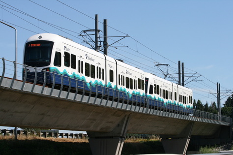
P.9
The development pattern stipulated in the Comprehensive Plan primarily focuses on shaping Seattle’s transportation facilities. Specifically, the designs will be geared to cater to the pedestrian nature of the urban centers and villages and the desire to connect these places with transit service. Seattle’s transportation planning is primarily governed by Seattle Department of Transportation SDOT with the aim to deliver a safe, reliable, efficient, and socially equitable transportation system that enhances Seattle's environment and economic vitality[xvi]. They develop policies and create action plans to make Seattle's transportation system accessible and convenient for transit users, pedestrians, bicyclists, motorists, and freight. They also encourage smart transportation choices by providing people with options to driving alone. They currently have several planning policies both being developed and already underway.
These include:
1. Transit Master Plan--a comprehensive and 20-year look ahead to the type of transit system that will be required to meet Seattle’s transit needs through 2030. It is an update to the 2005 Seattle Transit Plan, which identified key corridors linking urban villages and established performance standards for transit service[xvii]. The TMP expanded on that work and included evaluation of rail modes, rapid bus services, station design, and capital infrastructure. The first phase of TMP was completed in February 2011.
2. Seattle 2007 Bicycle Master Plan—a strategic set of actions, to be completed within 10 years, to make Seattle the best community for bicycling in the United States. By increasing support for bicycling, the city will make its transportation system more environmentally, economically, and socially sustainable. The Plan aims to create a Bicycle Facility Network and develop the supporting facilities and programs necessary to make bicycling a viable choice for a wide variety of trips[xviii]. Improving the convenience and safety of bicycling in the city will provide cost-effective, healthy, and convenient transportation for residents who bicycle. It will also increase social interaction on streets, offer alternatives to driving on congested roadways, and reduce pollution—public benefits that will make Seattle an even better place to live. It was last due to be updated in 2012.
3. Seattle Pedestrian Master Plan—A long-term action plan to make Seattle "the most walkable city in the nation". It establishes the policies, programs, and projects that will further enhance pedestrian safety, comfort, and access in all of Seattle’s neighborhoods. Through the Pedestrian Master Plan, Seattle will make its transportation system more environmentally, economically, and socially sustainable[xix].
4. Complete Streets--Seattle’s Complete Streets policy is about creating and maintaining safe streets for everyone. In 2007, the Seattle City Council passed Ordinance 122386, known as the Complete Streets ordinance, which directs Seattle Department of Transportation (SDOT) to design streets for pedestrians, bicyclists, transit riders, and persons of all abilities, while promoting safe operation for all users, including freight[xx,a]. This is the lens through which SDOT views the major maintenance and construction projects. A “Complete Street” entails: 1) Defined by Ordinance 122386 2)Includes improvements that balance the needs of all users 3) Considers the unique qualities of each street with a flexible approach to implementation[xx,b].
Housing Element
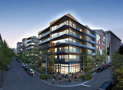
P. 10
It is within this element that the core values of maintaining social and economic equity among Seattle’s public come into play. The Comprehensive Plan guides its suggested housing provisions based on the estimate of the projected economic employment growth in Seattle. However, actual housing affordability is influenced in part by regional and local land use policies, development regulations and permit processes. Because Seattle’s housing market is influenced by the regional housing market, Seattle and other jurisdictions in the region need to be cohesive in their future development plans so that they can provide equally for all prospective additions to the city [xxi,a]. Yet the Plan does place particular attention to the role of multi-family units in accommodating many of these additions. This kind of residential development is often more affordable than ground-related housing due to the frequently smaller size of the units.
For the future of Seattle’s housing to accommodate the projected growth and maintain affordability, the goals of this element are to:
· Accommodate 47,000 additional households over the 20 years covered by the Plan
· Maintain housing affordability over the life of the Plan.
· Achieve greater predictability in project approval timelines, achievable densities and mitigation costs [xxi,b].
. The primary tool that will be vital to the achievement of these goals and play a key role in the planning for housing accommodations of Seattle’s future growth is the implementation of Incentive Zoning. This program is headed by the Seattle Planning Commission in furtherance of the City’s goal of working toward accommodating a significant amount of the region’s new jobs and housing growth in Seattle while also actively supporting urban sustainability and livability [xxii,a]. As the density of Seattle increases, a number of voluntary land use tools should be implemented to help offset the impacts of development, improve livability and respect neighborhood character.
Essentially, incentive zoning is a strategy that aims to encourage density sustainably by offering in exchange the provision public benefits such as affordable housing and other community amenities [xxii,b]. Aspects entailed by incentive zoning measures include density bonus programs—to stimulate infill development—and transfer development rights. One example of this is rewarding developments with increased floor area ratios (FARs). The City would first require a base FAR for developers but then incentivize them to add additional height to the project in exchange for a public benefit/amenity such as increased public housing, open space, or even historic preservation areas [xxii,c].
References:
i. Seattle Department of Planning and Development (last updated 2012) Retrieved from http://www.seattle.gov/dpd/planning/.
ii.(a,b,c)Seattle Department of Planning and Development (2005). Seattle Comprehensive Plan, Seattle, WA: Seattle
iii.Urban Village Element (updated 2012). Seattle Comprehensive Plan, Seattle, WA: Seattle
iv. Seattle DPD (updated 3/19/2010), Center City Seattle. Retrieved from www.seattle.gov/DPD/Planning/Center_City/Overview/ Retrieved 2/25/2013
v. Center City Public Realm Strategy (2010 September), Center City Seattle, Seattle DPD. Retrieved from www.seattle.gov/dpd/cms/groups/pan/@pan/@plan/@proj/documents/web_informational/dpdp020498.pdf
vi(a,b,c) Central Waterfront (2012 July) Center City Seattle, Seattle DPD Retrieved from
waterfrontseattle.org/downloads/CWC_Strategic_Plan_Final_7-11-12_Web_Version.pdf
vii (a,b,c). Seattle DPD (2002), CityDesign, Blue Ring Strategy. Retrieved from waterfrontseattle.org/downloads/CWC_Strategic_Plan_Final_7-11-
12_Web_Version.pdf
viii (a,b). Seattle DPD (2008), CityDesign, Pike and Pine Streetscape Conceptual Design Plan. Retrieved from http://www.seattle.gov/dpd/cms/groups/pan/@pan/@plan/@citydesign/documents/web_informational/dpdp015756.pdf
ix. Neighborhood Planning Element (2012). Seattle Comprehensive Plan, Seattle, WA: Seattle
x (a,b). First Hill Revitalization (2008), Seattle DPD. Retrieved from www.seattle.gov/DPD/Planning/First_Hill_Revitalization/Overview/
xi (a,b). Livable South Downtown (2006), Seattle DPD. Retrieved from www.seattle.gov/DPD/Planning/South_Downtown/Background/default.asp
xii (a,b). Downtown Zoning Changes (2008), Seattle DPD. Retrieved from www.seattle.gov/DPD/Planning/Downtown_Zoning_Changes/Background/default.asp
xiii (a,b). Yesler Terrace (2012 June), Seattle DPD. Retrieved from www.seattle.gov/dpd/Planning/YeslerTerrace/Overview/default.asp
xiv. Environment Element (2012). Seattle Comprehensive Plan, Seattle, WA: Seattle
xv (a,b,c,d). Urban Forest Management Plan (2007). Seattle reLeaf. Retrieved from www.seattle.gov/environment/documents/Final_UFMP.pdf
xvi. Transportation Element (2012). Seattle Comprehensive Plan, Seattle, WA: Seattle
xvii. Transit Master Plan (2012). Seattle Department of Transportation. Retrieved from www.seattle.gov/transportation/transitmasterplan.htm
xviii. Seattle Bicycle Master Plan (2012). Seattle Department of Transportation. Retrieved from www.seattle.gov/transportation/bikemaster07.htm
xix. Introduction: Pedestrian Master Plan (2012) Seattle Department of Transportation. Retrieved from www.seattle.gov/transportation/pedestrian_masterplan/default.htm
xx (a,b). Complete Streets in Seattle (2007). Seattle Department of Transportation. Retrieved from http://www.seattle.gov/transportation/completeStreets.htmxxi (a,b) Housing Element (2012). Seattle Comprehensive Plan, Seattle, WA: Seattle.
xxii (a,b,c) Seattle Incentive Zoning Report (2007). Seattle Planning Commission. Retrieved from http://www.seattle.gov/planningcommission/affordablehousing.htm
Images:
P.1 Center City Seattle. Retrieved from http://secure.surveymonkey.com/_resources/12513/7452513/795c9fab-bd8b-4989-8981-dfcd8eea1727.gif
P.2 Retrieved from http://licata.seattle.gov/wp-content/uploads/2012/07/img14.jpg
P.3 Seattle’s Blue Ring. Retrieved from http://musemcgill.files.wordpress.com/2012/06/seattle3.png
P.4 Pike and Pine Street Map. Retrieved from http://slog.thestranger.com/files/2008/10/pike_pine_map.jpg
P.5 Retrieved from http://www.seattlerex.com/wp-content/uploads/2011/08/pinestreet2-600x450.jpg
P.6 Retrieved from http://seattletimes.com/ABPub/2010/01/19/2010834704.jpg
P.7 Retrieved from http://farm5.staticflickr.com/4117/4851453661_4fd2587eb0_z.jpg
P. 8 Retrieved from http://www.seattle.gov/trees/images/skyline.jpg
P.9 Retrieved from http://upload.wikimedia.org/wikipedia/commons/2/21/2_car_train_to_Tukwila_(Sound_Transit_Central_Link).jpg
P.10 Retrieved from http://www.seattlemet.com/data/publicola-assets/2010/06/AVBQueenAnne2.jpg

.jpg)