Rail Road
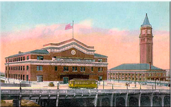
Union Station[2]
With the railroad came improvement of trade and growth in population throughout the Puget Sound region. Railroad Avenue, where the station was located, became an extremely busy place. To help alleviate rail congestion on Railroad Avenue, the Great Northern Tunnel was built in 1904 at the insistence of Seattle City Engineer Reginald H. Thomson. The Great Northern Tunnel extended for one-mile, running beneath downtown Seattle. At completion, the tunnel was the highest in the nation (not the longest) with a height of 28 feet and width of 30 feet. The finished tunnel was well ventilated, used electric lighting, and accommodated a double line of tracks. The work cost a total of $1,500,000 to build, and the Great Northern and the Northern Pacific Railroads as the primary users split the cost.[1] Union Station opened on May 20, 1911 and was used by both the Union Pacific and the Milwaukee Road System.[2] The Northern Pacific did not move or greatly improve their Seattle depot for the next 10 years because of the nation’s poor economic state. Both the Northern and Union Pacific went bankrupt. At the onset of the Klondike Gold Rush in 1897, Seattle finally emerged from economic depression.[3]
Gold Rush
With the
Klondike Gold Rush many people rushed west in hopes of catching transportation
to Alaska. However there were many western ports and Seattle wasn’t initially
the first choice of many people. Seattle’s Bureau of Information on August 30,
1897, devised a plan to promote Seattle to those traveling to Alaska. Thanks to
very well placed advertisement Seattle promoted their city as the obvious place
to go, stock up on supplies, and depart for the Yukon. In a very short amount
of time Seattle gained control over the trade with Alaska.[4] Thanks to the gold rush Seattle became full
of energy and purpose. The Klondike invigorated the economy. As with the other
gold rushes, generally the miners weren’t the ones who struck it rich but the
businessmen. Pioneer Square was the place of business in Seattle and was
thriving thanks to the Yukon. During the late 1890’s Seattle became the
financial center of the Pacific Northwest as a result of the Klondike Gold Rush. The amount of money exchanged on a
daily basis in Seattle by 1900 had grown by more than 400 percent, surpassing
both Portland and Los Angeles.[5] The amount of people attempting to reach Alaska due to the
gold rush between 1897 and 1900 exceeded 100,000, but only 40,000 ever reached
Dawson City, the center of the Gold Rush. Many of those who did not make it to
Alaska returned and settled in Seattle, finding a wealth of jobs for the
unemployed. The gold rush provided
a steady stream of wealth and immigrants via the railroads. In 1890, Seattle’s
population was 42,837, and by 1910 the population reached 237,194. Miners who
returned to Seattle invested their fortunes into businesses in the Pioneer
Square. A great example of this is John Nordstrom who invested $13,000 of gold
into a shoe store. This was the beginning of the Nordstrom department store.
Many companies capitalized on the their success during the gold rush and
transformed their small stores into major department stores.[3]
Street Cars and Transportation
Until just before World War II most citizens would commute to work using the city’s streetcar lines. Investors rushed to take advantage of the streetcar technology and invested heavily from 1888 to 1890. They hoped to make money from home seekers taking advantage of the rail line to new housing areas, but the population wasn’t growing much. In 1893 the depression arrived, bringing the economy of Seattle to a halt. Once the gold rush revitalized the economy, the Seattle Electric Company began purchasing, upgrading, and extending all of the bankrupt or struggling streetcar lines. This was just in time for the housing boom. Between 1900 and 1933, Seattle was able to develop and disperse along the lines of the streetcars. The first city to own a street railway was West Seattle, which purchased a private line in 1902. Seattle failed to buy the Seattle-Renton interurban in 1911 and in response build a streetcar line between downtown and Ballard in 1914. Aside from streetcars, people could travel all the way to Tacoma and Everett with interurban rail lines. The stops were fewer and less frequent than streetcars. By 1936, the Municipal Street Railway was operating 410 streetcars on 16 routes amounting to 231 miles of tracks. Starting as early as the 1920’s the use of streetcars for transportation in the city rapidly decreased thanks to increasing car ownership and the relocation of jobs outside the central part of the city. In order to improve the transportation system and get more people to start using public transportation, the city tried to implement a new plan in the mid 1930’s. John C. Beeler designed the proposal for the new system known as the “Beeler Plan”, and the plan was well received by the City Council but rejected by the voters in 1937. However, the future governor Arthur Langlie appealed to the Federal Government for financial aid. The Reconstruction Finance then loaned Seattle $10 million to pay off the streetcar debt and to implement a revised version of the Beeler Plan. The last streetcar in Seattle completed its final run on April 13, 1941.[7]
Residential Housing
There were very few houses built from 1892 to 1899, and most of the houses built at this time were either destroyed or severely altered. During this time the number of families seeking housing starts averaged just 350 houses and some years fewer than 150 houses. By the 1900’s the housing communities built along the rail lines were still waiting for their first residences. Thanks to the gold rush the population started growing rapidly by about 660 people per month. This led to the housing boom, and there were about 13,500 frame residences constructed from 1900 to 1905. The boom continues for the entire decade, and during the second half of the decade, 16,000 new houses were built. The Queen Anne style houses were popular for about 20 years but started to lose appeal at the turn of the century. By 1905, the popularity of Victorian house styles had ended after two decades. Around this time two-story foursquare and the Classic Box became the popular home style. The Colonial Revival style home and Seattle’s first Bungalows were built at the beginning of the century. During the second decade of the 1900’s, the Bungalows sold more than any other style. The streetcar lines allowed for the expansion of residential development. New residents built balloon frame houses with Yesler’s lumber, a practice that continued well into the 20th century. Carpenters used the balloon frame technique to construct practically all Seattle residences. The usual house built was a one or two story gabled house with little architectural ornament. If the houses were painted, they were almost always painted white. Through 1905 architects completed few individual designs of residences (aside from Seattle’s most expensive homes).. By 1905 the last Queen Anne style houses were no longer built and the Classic Box house style started dominating. The Classic Box is a foursquare house type. The name Classic Box or Seattle Box was named around 1975. After 1905, the popular Craftsman Bungalow was built in Seattle. It was first brought to the Puget Sound area about 1900 and is essentially a cottage (or small house) with low-pitched gable or hipped roof. At first the Bungalow’s were seen as summer homes and weren’t fully recognized as a year round residence until 1906. There was also the Prairie Style house that started appearing in Seattle about 1908. In 1920, there were about 50,000 automobiles registered in Seattle. Houses initially added unattached garages near their residence, but by the end of World War I, people started converting a portion of their houses to garages. [8]
City Beautiful Movement
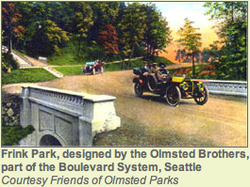
Frink Park[10]
The intentions behind the City Beautiful Movement, lead by the upper and middle class, were to address sanitation, minimize crime, and the population. By beautifying the city, the movement believed that the residents would be inspired and grow more loyal to Seattle. As the people’s sense of civic loyalty grew, the crime rate would diminish.[9] In 1903 the city of Seattle only owned five major parks. The most notable contributor to the City Beautiful Movement in Seattle was John C. Olmsted who is considered the father of landscape architecture in the United States. John Olmstead could not have come at a better time due to the amount of wealth Seattle had acquired from the Klondike Gold Rush. John Olmstead created a master plan in 1903 that mapped out a 20-mile-long system of parks and boulevards from Woodland Park to Discovery Park. The Olmstead brothers planned and put together a park system that within 10 years was unmatched by most cities. By 1937 the Olmstead brothers had designed 37 parks and playgrounds that were a major focus of the park development project. In their 1908 report they recommended that the recently annexed lands require areas focused toward young children and women with babies within a half-mile of every home. Olmstead’s design aimed to keep the parks unified in look while taking advantage of the natural topography to give each park its individuality. The citizens fully and actively supported Olmstead’s plan. The citizens passed bonds totaling $3.5 million (equivalent to $57 million in 1999) in the eight years following the proposal for park enhancement. This money lead to Seattle acquiring more land, doubling the park lands to more than 1,0000 acres.[10]
World War I
During World War I, the focus of the nation was fighting the war. Seattle in particular experienced tremendous growth but not much development. The city’s lumber resources were in demand during the war. The city expanded their shipbuilding industry, and the Boeing company began as a partnership between a naval engineer and a lumberman.[11] At the end of the war Seattle had produced 20 percent of the nations wartime ship tonnage.[12] Seattle’s population grew rapidly due to the large number of jobs during this time, attracting especially those interested in the aerospace and shipbuilding industries. [11]
Zoning
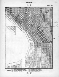
Plate 10 from 1923 Zoning Ordinance[14]
The size of Seattle grew rapidly over the first two decades of the 20th century. Between 1905 and 1910, Seattle annexed eight small municipalities almost doubling in size. The eight areas annexed included: Ballard, Columbia, Georgetown, Ravenna, South Park, South Seattle, Southeast Seattle, and West Seattle.[13] The very first zoning ordinance passed in 1923 and, with many amendments, was used as the basis for land use regulation until 1957. The zoning was initially created to survey the city in terms of land use. The draft ordinance written in 1923 was composed by a city engineer, the Superintendent of Buildings, one parks trustee, and six others appointed by the Mayor.[14]
Great Depression
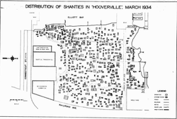
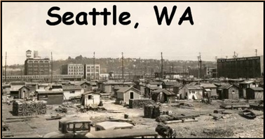
Map of Seattle's main "Hooverville" [15]
During the early 1930’s, the Great Depression hit, and a housing crisis accompanied the recession. Dozens of so called “Hoovervilles” started popping up all over Washington. They were named “Hoovervilles” as a political label to place the blame for the poor economical conditions on President Herbert Hoover and the Republican Party. Seattle’s main Hooverville was one of the largest, longest –lasting, and best documented. The Hooverville stood for ten years from 1931 to 1941, spanned 9 acres, and housed 1,200 people. The Hooverville was even considered a community, including an unofficial mayor. Many homeowners lost their homes during the depression because they could not afford the mortgage or pay taxes. People were forced onto the streets or to squeeze in a home with relatives. The main Hooverville of Seattle started as a group of huts next to Elliot Bay south of “skid road” (refers to Pioneer Square). The Seattle police burned the Hooverville twice, but the residents rebuilt it. In 1932 a mayor took office, which gave the Hooverville a measure of tolerance that allowed the area to survive and grow. In 1934, a survey counted 639 residents and 500 self-built one-room domiciles. Most inhabitants were men, and the residents were highly diverse. The social atmosphere was remarkable and described as “an ethnic rainbow where men of many colors intermingled in shabby camaraderie” by Donald Roy, a sociology graduate student who studied the community. There were other Hoverville’s scattered: one in the Interbay area (where the city used to dump garbage) and two along 6th Avenue in South Seattle. The city’s Department of Health estimates that 4,000 to 5,000 people were currently living in various shack towns. On the eve of World War II, the city no longer tolerated Hovervilles, and in 1941 the Seattle Department of Health established the Shack Elimination Committee that located 1687 shacks in five main colonies and many smaller ones. The residents were given notice to leave, and, on May 1, police officers doused the little structures that lasted a full decade with kerosene and burned Seattle’s Hoovervilles to the ground.[15]
Seattle's main "Hooverville" [16]
Significant Structures
Smith Tower
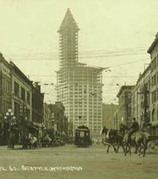
Smith Tower[17]
Smith Tower: The first building of significance built in this time period was Smith Tower. The tower officially opened on July 4, 1914. What made the structure famous was the 462-foot height and 42 stories. At the time of completion, the tower was the tallest building in the country outside of New York. This monument was recognized as the Northwest’s best-loved skyscraper. Smith tower was considered a prominent landmark that even aided ships in docking while traveling through the Elliot Bay. There is even a legend tied to this building called the “Wishing Chair”, which is a chair located on the 35th floor in the popular Chinese Room. The legend asserts that any women who sits on the chair and makes a wish to be married will be married within one year. Smith tower serves as an example of neoclassical architecture, where the first two floors and the exterior are made from granite. To the rest of the floors, the builders applied a smooth terra cotta exterior. The tower boasts 2,314 windows, is supported by 1,276 pillars, and weighs approximately 48,650 tons.[17]
Seattle Tower
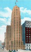
Seattle Tower[18]
The Seattle Tower, previously known as The Northern Life Tower, is a landmark in downtown Seattle. The 27-story tower at 1218 3rd Avenue was built for the Northern Life Insurance Company. The building was finished on March 18, 1929, costing about $2 million to build and a year to build. The Northern Life Insurance Company who paid for the building was founded in Seattle in 1905 but disappeared through various mergers since the company was sold in 1977. The building’s name was changed to The Seattle Tower and still exists today as City of Seattle Landmark number 137. To make the building even more unique, the designers added more than 300 flood light units to shoot rays upward, creating a beautiful and effective aurora borealis effect. This led the locals to calling the building “the Northern Lights.” The lights were dismantled in 1942. Even though Seattle Tower is smaller than Smith Tower at 27 stories, the Seattle Tower is built at a higher elevation making the Seattle Tower appear as the tallest building in the skyline for decades just as the builders intended.[18
Washington Lake Floating Bridge
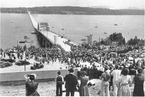
Lake Washington Floating Bridge[19]
In the late 1930s a plan to build a bridge connecting Spokane over saltwater began through nearly $4 million of funding from the Public Works Administration plus a bond of $5.5 million to be paid back through bridge tolls. On July 2, 1940, the Lake Washington Floating Bridge opened, expanding from the Mount Baker neighborhood of Seattle over Mercer Island to a point south of Bellevue. Initially the bridge carried the title US 10 but was later named Interstate 90. At the time, the bridge was the largest floating structure ever built. The bridge was designed by engineer Homer Haley and floats on hollow concrete pontoons, a most innovative technology at the time. The bridge cost a total of $8,854,000 to build. In all, the bridge saves an hour of commuting time to Seattle. The bridge sunk in a storm on November 25, 1990, during a storm but was later rebuilt.[19]L
References
1. Daryl C. McClary, Great Northern Tunnel -- Seattle, http://www.historylink.org/index.cfm?DisplayPage=output.cfm&file_id=4029, (November 2002)
2. American-rails, Seattle’s Union Station, http://www.american-rails.com/union-station.html,
3. Heather M. Macintosh, Northern Pacific Railroad and Seattle Development, http://www.historylink.org/index.cfm?DisplayPage=output.cfm&file_id=1734, (October 1999)
4. National Park Service, Hard Drive to the Klondike: Promoting Seattle During the Gold Rush Historic Resource Study for Klondike Gold Rush National Historical Park Chapter two, http://www.nps.gov/klse/forteachers/hrs2.htm
5. National Park Service, Hard Drive to the Klondike: Promoting Seattle During the Gold Rush Historic Resource Study for Klondike Gold Rush National Historical Park Chapter three, http://www.nps.gov/klse/forteachers/hrs3.htm
6. The Klondike Gold Rush of 1898: A Teacher’s Guide to the Last Grand Adventure, http://www.nps.gov/nr/twhp/wwwlps/lessons/55klondike/55facts4.htm (1993).
7. Walt Crowley, Street Railways in Seattle, http://www.historylink.org/index.cfm?DisplayPage=output.cfm&file_id=2707 (October 2000).
8. Greg Lange, Early Seattle Neighborhood Buildings, http://www.seattle.gov/neighborhoods/preservation/ContextEarlySeattleBldgs.pdf (2005)
9. History of Urban Agriculture, City Beautiful Movement, 1890–1910, http://sidewalksprouts.wordpress.com/history/city-beautiful-movement/
10. David B. Williams, Olmstead Parks in Seattle, http://www.historylink.org/index.cfm?DisplayPage=output.cfm&File_Id=1124 (May 1999)
11. Seattle, History, http://www.city-data.com/world-cities/Seattle-History.html
12. City of Seattle, Brief History of Seattle, https://www.seattle.gov/cityarchives/Facts/history.htm
13. Office of the City Clerk Legislative Department, Archives Gazette, http://www.seattle.gov/CityArchives/About/Gazette/gazette14.pdf (Winter 2003)
14. Seattle’s Land Use Code, https://seattleslandusecode.wordpress.com/page/32/ (2011)
15. James Gregory, Hoovervilles and Homelessness, http://depts.washington.edu/depress/hooverville.shtml (2009)
16. America’s Great Depression 1930’s, http://freepages.genealogy.rootsweb.ancestry.com/~elkridge/DepressionYears.htm
17. John Pastier, Smith Tower (Seattle), http://www.historylink.org/index.cfm?DisplayPage=output.cfm&file_id=4310 (July 2004).18. Dotty DeCoster, Northern Life/Seattle Tower (Seattle), http://www.historylink.org/index.cfm?DisplayPage=output.cfm&file_id=9633 (December 2010).
19. Greg Lange, Lake Washington Floating Bridge is dedicated on July 2, 1940, http://www.historylink.org/index.cfm?DisplayPage=output.cfm&file_id=682 (January 1999).
